wat bedoel je met "noordelijke route" niet bemoedigend? ik dacht juist dat dat misschien beter was aangezien je die wash niet door moet die tot 1 meter diep kan zijn
ik zelf zat al te denken om na Coalmine Canyon terug te keren via Tuba City en daar de Noordelijke toegang te nemen... ik heb het uitgerekend via Google maps en dat zou in ieder geval tijdswinst opleveren ...het enige rare is dat wanneer ik bereken via Google Maps hij je rondstuurt en niet de afslag lat nemen die hieronder in beide beschrijvingen aangegeven staat ...
Er zijn inderdaad heel veel wegen noordelijk dus een GPS zou niet slecht zijn; een andere optie is voor mocht je een ipad hebben, dat is copilot USA; de app kost 14€ en je kan er zowel adressen als GPS coordinaten inzetten (enige probleem je kan op voorhand geen routes berekenen)
hier op het forum vond ik de volgende beschrijving:
1. On highway 160 from Kayenta turn left near milemarker 344 which is located about 1.1 miles after you pass the Elephant Feet (two large columns of sandstone at the side of the road - you will know them when you see them). After you turn left you will be passing behind the back of a house almost immediately after leaving the road and the dirt road you are on will continue.
2. Reset your odometer to zero after you turn off of highway 160!
3. After travelling about 3.1 miles on this dirt road it will appear to fork into two well used sections. Take the right fork.
4. After you have travelled 5.9 miles the road will fork. Take the right fork.
5. At 9.5 miles you will see a windmill on your right. If you see this windmill then you are where you should be.
6. At 11.7 miles the Blue Canyon cliffs will appear in the distance. You are almost there.
7. At 14.3 miles you will reach Blue Canyon. A spur road that comes off the main road to the left will allow you to drive into the Blue Canyon area.
en op
http://www.americansouthwest.net/ het is minder gedetailleerde
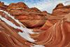
Route: In the north, the unsigned road starts by descending a slickrock hill behind the trading post, then flattens out and for most of the first 4 miles is either uneven or rutted or both, though the track is wide and well used, by the nearby residents. Conditions improve once the road climbs out of the valley and heads south across a treeless plateau; the surface is now smoother, the route narrower and less traveled, with long straight sections and several minor dry wash crossings. Now there is no sign of any habitation, only a few lesser tracks at intervals, but also no sign of badlands, just gently rolling, grassy or sandy plains. After 10.9 miles the track starts a two stage descent to the floor of Moenkopi Wash, initially over the plateau edge into a wide basin, where hoodoos and cliffs come suddenly into view to the east. The route crosses a tributary wash after 12.7 miles, passes a side track to the Blue Canyon formations then curves south, reaching Moenkopi Wash after 14.2 miles
Blue Canyon: The short side track heads across bushy mud flats to the edge of the closest group of hoodoos, where it forks; the right branch follows the south edge while the other route runs along the north side towards the most extensive groups of formations. Lesser tracks split off in various directions and 4WD vehicles seemingly drive anywhere over the flat ground between the rocks. The hoodoos are centered on a flat-floored valley about half a mile wide lined by two low ridges, with formations along both sides of each ridge, while the top (northeast) edge of the valley is bordered by higher cliffs of greenish-yellow rocks, at the edge of a prominent mesa. Here are found scattered, tall, graceful hoodoos; greenish pillars below brown or white cap rocks. The hillside slopes quite steeply and some climbing is necessary to see the best hoodoos. The same rock layer is exposed in many other places hereabouts including on the south side of Moenkopi Wash but in this location the eroded band is steeper and hence thinner, with fewer formations.